|
 |
Interesting Map (large jpeg 0RgY)
|
|
|
|
|
Professional Poster
Join Date: Jul 2001
Location: Dis
Status:
Offline
|
|
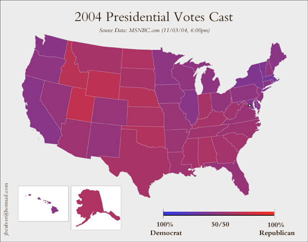
What red and blue states?
BG
|
|
I do not feel obliged to believe that the same God who has endowed us with sense, reason, and intellect has intended us to forgo their use. -Galileo Galilei, physicist and astronomer (1564-1642)
|
| |
|
|
|
|
|
|
|
Addicted to MacNN
Join Date: Mar 2001
Location: The Rockies
Status:
Offline
|
|
Yeah. I don't think it's the states - that's too broad of a divide. But it's the attitude of individuals that seems so polarized. I truly can't understand how anyone could have voted for Bush, and I'm sure the Bush supporters truly can't understand how anyone could have voted for Kerry. We just have totally different world views.
|
|
|
| |
|
|
|
|
|
|
|
Posting Junkie
Join Date: Mar 2002
Location: Alexandria, VA
Status:
Offline
|
|
I think the county map (in pdf) is more meaningful.
|
|
|
| |
|
|
|
|
|
|
|
Addicted to MacNN
Join Date: Mar 2001
Location: The Rockies
Status:
Offline
|
|
Originally posted by SimeyTheLimey:
I think the county map (in pdf) is more meaningful.
But even that's winner-take-all. Even in those rural areas there are plenty of Democrats, and in the cities there are plenty of Republicans. Showing the counties (or states) as just red or blue implies that it's "all" one or the other, when in reality it might be 55-45, and I think that's the point of BG's purple map.
|
|
|
| |
|
|
|
|
|
|
|
Addicted to MacNN
Join Date: Mar 2001
Location: USA
Status:
Offline
|
|
The map Simey pointed to does a good job of showing a misconception about Texas: it's not all Republican. Further, you can look at how many other states are nothing but pro-Bush.
As an aside, my neighbors had a big ol' Kerry sticker on their gas guzzling mini van, but by the time I got home from work on Wednesday (around 4:45pm), they had already taken the sticker off.
Heh.
Maury
|
|
|
| |
|
|
|
|
|
|
|
Senior User
Join Date: May 2002
Status:
Offline
|
|
Originally posted by SimeyTheLimey:
I think the county map (in pdf) is more meaningful.
Too bad it doesn't show the gradient.
However, one thing of note: everywhere that's industrialized went to kerry, while most the backward villages went to bush.
You know, the bosnia war was a result of a backwards, agressive homogeneous rural groups attacking the diverse urban population.
|
|
|
| |
|
|
|
|
|
|
|
Addicted to MacNN
Join Date: Mar 2001
Location: USA
Status:
Offline
|
|
Originally posted by dialo:
Too bad it doesn't show the gradient.
However, one thing of note: everywhere that's industrialized went to kerry, while most the backward villages went to bush.
You know, the bosnia war was a result of a backwards, agressive homogeneous rural groups attacking the diverse urban population.
Oh my freaking crap, did you really just say that? "everywhere that's industrialized went to kerry, while most the backward villages went to bush"?!?!?
I hope you're trying to be a smartarse and not serious -- otherwise you need to do some research about the locations of the various and sundry refineries, chemical plants, petrol processing centers, etc scattered ALL OVER the country, especially here in Texas/LA.
Once you do that homework, you'll see your comment is 100% false and the inverse is 100% true.
Maury
|
|
|
| |
|
|
|
|
|
|
|
Addicted to MacNN
Join Date: Mar 2001
Location: The Rockies
Status:
Offline
|
|
One of the problems with the county map, and the state map for that matter, is that it suggests that there are a lot more Republicans than there really are. The fact is, many of those red counties just don't have many people in them, whereas many of the blue ones have lots of people. Unfortunately the maps adjusted for population look too strange:

|
|
|
| |
|
|
|
|
|
|
|
Addicted to MacNN
Join Date: Apr 2001
Location: Landlockinated
Status:
Offline
|
|
Originally posted by BRussell:
Yeah. I don't think it's the states - that's too broad of a divide. But it's the attitude of individuals that seems so polarized. I truly can't understand how anyone could have voted for Bush, and I'm sure the Bush supporters truly can't understand how anyone could have voted for Kerry. We just have totally different world views.
See, you are so brilliant BRussell that you are able to be wrong but correct yourself by the end of your paragraph.
See, I CAN see why someone would vote Kerry. And apparently you can see why someone would vote Bush.
"We just have totally different world views."
(OK, maybe not totally different, but you get my meaning. Thinking people can disagree.)
|
|
[ sig removed - image host changed it to a big ad picture ]
|
| |
|
|
|
|
|
|
|
Addicted to MacNN
Join Date: Jan 2001
Location: The Sar Chasm
Status:
Offline
|
|
Originally posted by RAILhead:
The map Simey pointed to does a good job of showing a misconception about Texas: it's not all Republican.
Teh People's Republic of Austin Represent! 
|
 When a true genius appears in the world you may know him by this sign, that the dunces are all in confederacy against him.
 -- Jonathan Swift.
|
| |
|
|
|
|
|
|
|
Addicted to MacNN
Join Date: Apr 2001
Location: Landlockinated
Status:
Offline
|
|
Originally posted by dialo:
However, one thing of note: everywhere that's industrialized went to kerry, while most the backward villages went to bush.
Hmm... guess I am just in a backward village. I'm not industrialized, I guess. I must not be typing this on a computer since we don't have that fancy electricity stuff.
Of course BRussell (last I knew - may have moved) lives pretty close to me, is his part of Montana more industrialized and forward?
Seriously, until you realize that someone can disagree with you without being ignorant, stupid, backward, etc., you'll never truly understand how to get things done.
The other things you must realize is that the red parts of the country bring lots of things to the blue parts and vice versa. Food doesn't come from grocery stores, after all. And sea food doesn't come from freshwater lakes in landlocked states.
|
|
[ sig removed - image host changed it to a big ad picture ]
|
| |
|
|
|
|
|
|
|
Senior User
Join Date: May 2002
Status:
Offline
|
|
Originally posted by RAILhead:
Oh my freaking crap, did you really just say that? "everywhere that's industrialized went to kerry, while most the backward villages went to bush"?!?!?
Yeah, I did.
I hope you're trying to be a smartarse and not serious -- otherwise you need to do some research about the locations of the various and sundry refineries, chemical plants, petrol processing centers, etc scattered ALL OVER the country, especially here in Texas/LA.
I lived in texas, rural texas and houston, during the mid 90s. Don't preach to me about what is or is not in texas.
You republicans better expect a backlash from the hate you've been spouting the past couple of days. From the racist anti-Black comments on this board and elsewhere, to multiple repub bloggers saying that liberals should go **** themselves to "Bush wins, Fags lose, ha ha ha, bomb iraq!" graffiti seen by a buddy of mine this morning, the bigots better expect the **** to hit the fan. If you want it to be nice, you better take the time to tell your lot to STFU and play nice before you piss too many people off.
|
|
|
| |
|
|
|
|
|
|
|
Addicted to MacNN
Join Date: Mar 2001
Location: The Rockies
Status:
Offline
|
|
Originally posted by davesimondotcom:
See, you are so brilliant BRussell that you are able to be wrong but correct yourself by the end of your paragraph.
See, I CAN see why someone would vote Kerry. And apparently you can see why someone would vote Bush.
"We just have totally different world views."
(OK, maybe not totally different, but you get my meaning. Thinking people can disagree.)
Haha, I'm right even though I'm wrong. The quintessential Kerry voter!
Yeah, I can understand it. What I meant to say is not that I can't possibly understand it, just that blue voters and red voters do seem to just see the world through different lenses. There seem to be some fundamental differences beyond just a simple choice for politician. I don't know, maybe I'm just falling for the Crossfire-induced hype and we're not really all that different. Who knows. There you go, another flip-flop!
|
|
|
| |
|
|
|
|
|
|
|
Professional Poster
Join Date: Jul 2001
Location: Dis
Status:
Offline
|
|
Originally posted by SimeyTheLimey:
I think the county map (in pdf) is more meaningful.
BRussel gets it, you don't. The only county by county results that I know of that show the "shades of gray" are at CNN (click on the individual states to see). Though it is problematic, too. instead of red-violet-blue it uses red-white-blue. Best way to describe the difference is with a equations, I think. The coloration vector, C is determined as followed (assuming 24 bit color):
First post: C = Bush% * 255 R + Kerry% * 255* Bu
CNN: If (Bush% - Kerry%) > 0 then C = 255 R + 2 * (1 - Bush%)*255*( Bu + G), otherwise C = 255 Bu + 2 * (1 - Kerry%)*255*( R + G)
I may not have the CNN equation exactly right, but they also have the raw data. Does anyone here care to make a county by county map that is actually comparable to take the place of the useless map from Simey?
BlackGriffen
|
|
I do not feel obliged to believe that the same God who has endowed us with sense, reason, and intellect has intended us to forgo their use. -Galileo Galilei, physicist and astronomer (1564-1642)
|
| |
|
|
|
|
|
|
|
Mac Elite
Join Date: Oct 1999
Location: Placerville, CA
Status:
Offline
|
|
Originally posted by davesimondotcom:
...until you realize that someone can disagree with you without being ignorant, stupid, backward, etc....
Geneally speaking this is true, but this specific case is quite the exception - those who voted for bush are complete fools.
|
|
|
| |
|
|
|
|
|
|
|
Addicted to MacNN
Join Date: Apr 2001
Location: Landlockinated
Status:
Offline
|
|
Originally posted by deedar:
Geneally speaking this is true, but this specific case is quite the exception - those who voted for bush are complete fools.
Hey, keep it up, if you want.
You'll keep losing.
|
|
[ sig removed - image host changed it to a big ad picture ]
|
| |
|
|
|
|
|
|
|
Posting Junkie
Join Date: Mar 2002
Location: Alexandria, VA
Status:
Offline
|
|
Originally posted by BlackGriffen:
BRussel gets it, you don't. The only county by county results that I know of that show the "shades of gray" are at CNN (click on the individual states to see). Though it is problematic, too. instead of red-violet-blue it uses red-white-blue. Best way to describe the difference is with a equations, I think. The coloration vector, C is determined as followed (assuming 24 bit color):
First post: C = Bush% * 255 R + Kerry% * 255* Bu
CNN: If (Bush% - Kerry%) > 0 then C = 255 R + 2 * (1 - Bush%)*255*(Bu + G), otherwise C = 255 Bu + 2 * (1 - Kerry%)*255*(R + G)
I may not have the CNN equation exactly right, but they also have the raw data. Does anyone here care to make a county by county map that is actually comparable to take the place of the useless map from Simey?
BlackGriffen
No, I get it, and as a matter of fact a few weeks ago I posted a graduated county map. I just haven't seen one from this election yet. The reason why I don't think the state maps are very representative is that the resolution is too big.
What I am thinking is this. Suppose you live in a large state that has one large urban area. 50% of the population live in the urban area, 50% live in the rest of the state. That would color the entire state purple making you think that means that Republicans and Democrats live and work together. But those people could be 200 miles apart from one another. They never speak or interact with one another. But you won't know that by looking at an entire state painted purple.
Compare that with a county map -- even one that is binary red/blue. You get some sense of where people of different parties rub shoulders with one another. It turns out that Democrats tend to live concentrated in the cities, with Republicans in the rural areas, and the suburbs mixed.
Squint your eyes and you can see this pattern even in a binary map. However, the gradated county map I posted a few weeks ago (from the 2000 election) made it even clearer. The urban areas are overwhelmingly Democrat, and rural was overwhelmingly Republican. We rub shoulders mostly in the suburbs.
|
|
|
| |
|
|
|
|
|
|
|
Clinically Insane
Join Date: Apr 2003
Location: 46 & 2
Status:
Offline
|
|
Originally posted by dialo:
Too bad it doesn't show the gradient.
However, one thing of note: everywhere that's industrialized went to kerry, while most the backward villages went to bush.
You know, the bosnia war was a result of a backwards, agressive homogeneous rural groups attacking the diverse urban population.
those grapes will become less bitter when you finally decide to swallow. So, are you going to spit or swallow?
|
|
"Those who expect to reap the blessings of freedom must, like men, undergo the fatigue of supporting it."
- Thomas Paine
|
| |
|
|
|
|
|
|
|
Addicted to MacNN
Join Date: Mar 2001
Location: USA
Status:
Offline
|
|
Originally posted by dialo:
Yeah, I did.
I lived in texas, rural texas and houston, during the mid 90s. Don't preach to me about what is or is not in texas.
You republicans better expect a backlash from the hate you've been spouting the past couple of days. From the racist anti-Black comments on this board and elsewhere, to multiple repub bloggers saying that liberals should go **** themselves to "Bush wins, Fags lose, ha ha ha, bomb iraq!" graffiti seen by a buddy of mine this morning, the bigots better expect the **** to hit the fan. If you want it to be nice, you better take the time to tell your lot to STFU and play nice before you piss too many people off.
Someone call the Doc and get this man a tranq -- he's goin' off the deep end! What the crap are you TALKING about? Where did I say anything racist, about "fags," or any of the other vitriol you spewed?
As for when you lived in Texas in the 90's, you must not have gotten around much. Did you forget about all the refineries in Pasadena? The whiole friggin city is nothing but plants, as well as Texas City, Deer Park and other. BP? Schenectady? DOW-freaking-Chemical? ExxonMobile -- and the list goes on.
")
|
|
|
| |
|
|
|
|
|
|
|
Clinically Insane
Join Date: Apr 2003
Location: 46 & 2
Status:
Offline
|
|
Originally posted by RAILhead:
Someone call the Doc and get this man a tranq -- he's goin' off the deep end! What the crap are you TALKING about? Where did I say anything racist, about "fags," or any of the other vitriol you spewed?
As for when you lived in Texas in the 90's, you must not have gotten around much. Did you forget about all the refineries in Pasadena? The whiole friggin city is nothing but plants, as well as Texas City, Deer Park and other. BP? Schenectady? DOW-freaking-Chemical? ExxonMobile -- and the list goes on.
Stop feeding the bigoted troll, he's still got those grapes to deal with.  
|
|
"Those who expect to reap the blessings of freedom must, like men, undergo the fatigue of supporting it."
- Thomas Paine
|
| |
|
|
|
|
|
|
|
Senior User
Join Date: May 2002
Status:
Offline
|
|
Originally posted by MacNStein:
Stop feeding the bigoted troll, he's still got those grapes to deal with.
Look. I got called a 'bigot' by a racist who thinks Black americans are ignorant.
|
|
|
| |
|
|
|
|
|
|
|
Clinically Insane
Join Date: Apr 2003
Location: 46 & 2
Status:
Offline
|
|
Originally posted by dialo:
Look. I got called a 'bigot' by a racist who thinks Black americans are ignorant.
Of course all Blacks aren't ignorant, only the liberal ones... same goes with the liberal whites. 
So, spit or swallow?
|
|
"Those who expect to reap the blessings of freedom must, like men, undergo the fatigue of supporting it."
- Thomas Paine
|
| |
|
|
|
|
|
|
|
Addicted to MacNN
Join Date: May 1999
Location: New York City
Status:
Offline
|
|
city folks and country folks can't agree
must be the water
|
|
|
| |
|
|
|
|
|
|
|
Professional Poster
Join Date: Mar 2002
Status:
Offline
|
|
Originally posted by BRussell:
One of the problems with the county map, and the state map for that matter, is that it suggests that there are a lot more Republicans than there really are. The fact is, many of those red counties just don't have many people in them, whereas many of the blue ones have lots of people. Unfortunately the maps adjusted for population look too strange:
There is even more important reason that your map is wrong.
It assumes that all Blue states are Democrat. They are not. One example, if I recall correctly, California was 55% Dem, and 45% Republican. That is only a 10% difference. You have a huge Blue blob on the left hand side representing the Population of California which has only 10% more Democrats than Repulicans.
|
|
|
| |
|
|
|
|
|
|
|
Registered User
Join Date: Mar 2000
Location: Garden of Paradise Motel, Suite 3D
Status:
Offline
|
|
Originally posted by SimeyTheLimey:
I think the county map (in pdf) is more meaningful.
Thanks for the link. First one I've seen this time.
Boy is it different from last time!
|
|
|
| |
|
|
|
|
|
|
|
Registered User
Join Date: Mar 2000
Location: Garden of Paradise Motel, Suite 3D
Status:
Offline
|
|
Originally posted by dialo:
agressive homogeneous rural groups
Man, that's insensitive. Leave the gay folks out of this argument. I don't care if they're homogeneous or not, they still have a right to express their opinion by voting. Geez.
Also, in BG's original map, notice how the country looks almost PINK. A coincidence? I think not.
(
Last edited by finboy; Nov 4, 2004 at 05:06 PM.
)
|
|
|
| |
|
|
|
|
|
|
|
Baninated
Join Date: Jul 2002
Location: The Moon
Status:
Offline
|
|
Originally posted by SimeyTheLimey:
I think the county map (in pdf) is more meaningful.
Indeed. Kept the link. And the PDF.
Thanks.
|
|
|
| |
|
|
|
|
|
|
|
Professional Poster
Join Date: Oct 1999
Location: :ИOITAↃO⅃
Status:
Offline
|
|
Here's another effort at a population-adjusted map:

But yeah, I'd like to see the ultimate map:
* county-by-county
* adjusted for population
* colored by intensity of red/blue victory
|
|
|
| |
|
|
|
|
|
|
|
Baninated
Join Date: Dec 2000
Location: Capital of the World
Status:
Offline
|
|
What's up with those deformed USA maps ?
I think it is an attempt by liberal mapmakers inorder to make their crushing defeat look less bad than it actually was in reality.

|
|
|
| |
|
|
|
|
|
|
|
Professional Poster
Join Date: Oct 1999
Location: :ИOITAↃO⅃
Status:
Offline
|
|
Here's the best one yet, showing county-by-county, taking population into account:

Only remaining flaw is that it doesn't color by intensity of the red/blue victory.
|
|
|
| |
|
|
|
|
|
|
|
Posting Junkie
Join Date: Mar 2002
Location: Alexandria, VA
Status:
Offline
|
|
Originally posted by Mithras:
Here's the best one yet, showing county-by-county, taking population into account:
Proof of what we always suspected: Democrats live in really tall apartment buildings and condos.
|
|
|
| |
|
|
|
|
|
|
|
Addicted to MacNN
Join Date: Mar 2001
Location: USA
Status:
Offline
|
|
Originally posted by Mithras:
Here's the best one yet, showing county-by-county, taking population into account:
img snipped
Only remaining flaw is that it doesn't color by intensity of the red/blue victory.
Whoa, holy crap -- that's cool, where'd you get it?
Maury
|
|
|
| |
|
|
|
|
|
|
|
Professional Poster
Join Date: Oct 1999
Location: :ИOITAↃO⅃
Status:
Offline
|
|
Maury, I got it from a comment on DailyKos (horrors!). I asked for the source, & will pass it along if I get it.
One more neat one, basically the purple-by-county:

|
|
|
| |
|
|
|
|
|
|
|
Addicted to MacNN
Join Date: Mar 2001
Location: The Rockies
Status:
Offline
|
|
Thanks Mithras. What's interesting to me about the shaded county map is that you see that the south actually still is quite purple. I suppose that has to do with the racial divide in those states, with lots of blacks voting for Democrats, but enough whites voting for republicans for the republicans to win. Still, it's not like the south is bright red.
It's the heartland midwest and parts of the rocky mtn west that are bright red. Utah appears to be the reddest state, with Wyoming a close second. There are just hardly any Democrats there.
And what are those couple of bright blue counties in the middle - looks like nebraska maybe? South Dakota?
Cool thread.
|
|
|
| |
|
|
|
|
|
|
|
Professional Poster
Join Date: Jun 2003
Location: Hyrule
Status:
Offline
|
|
Originally posted by BRussell:
Thanks Mithras. What's interesting to me about the shaded county map is that you see that the south actually still is quite purple. I suppose that has to do with the racial divide in those states, with lots of blacks voting for Democrats, but enough whites voting for republicans for the republicans to win. Still, it's not like the south is bright red.
.
WHITE POWAAA!!!
|
|
Aloha
|
| |
|
|
|
|
|
|
|
Professional Poster
Join Date: Jan 2000
Location: south
Status:
Offline
|
|
|
|
|
|
| |
|
|
|
|
|
|
|
Junior Member
Join Date: Sep 2004
Location: The Land of Left
Status:
Offline
|
|
Originally posted by shmerek:

Fix'd
|
|
|
| |
|
|
|
|
|
|
|
Banned
Join Date: Sep 2004
Status:
Offline
|
|
Originally posted by BlackGriffen:
What red and blue states?
What a stupid map.
|
|
|
| |
|
|
|
|
|
|
|
Clinically Insane
Join Date: Apr 2003
Location: 46 & 2
Status:
Offline
|
|
Originally posted by Lefterer Guy:
Fix'd
So, you all going to do it (please), or are you just going to keep bitching?
I'll help you guys get this going, let me know how I can be of assistance.
|
|
"Those who expect to reap the blessings of freedom must, like men, undergo the fatigue of supporting it."
- Thomas Paine
|
| |
|
|
|
|
|
|
|
Mac Elite
Join Date: Apr 2000
Status:
Offline
|
|
Originally posted by SimeyTheLimey:
I think the county map (in pdf) is more meaningful.
Man, is the big part of Alaska just one big county? freaky.
|
|
|
| |
|
|
|
|
|
|
|
Junior Member
Join Date: Sep 2004
Location: The Land of Left
Status:
Offline
|
|
Originally posted by MacNStein:
So, you all going to do it (please), or are you just going to keep bitching?
I'll help you guys get this going, let me know how I can be of assistance.
PLEASE! Please help us leave. Not physically, but help our states secede. Help evangelize our cause to Republicans. Make the democrats around you come here and help our cause. Much appreciated.
Thanks.
|
|
|
| |
|
|
|
|
|
|
|
Clinically Insane
Join Date: Apr 2003
Location: 46 & 2
Status:
Offline
|
|
Originally posted by Lefterer Guy:
PLEASE! Please help us leave. Not physically, but help our states secede. Help evangelize our cause to Republicans. Make the democrats around you come here and help our cause. Much appreciated.
Thanks.
Done! I'll do everything in my power. 
|
|
"Those who expect to reap the blessings of freedom must, like men, undergo the fatigue of supporting it."
- Thomas Paine
|
| |
|
|
|
|
|
|
|
Moderator Emeritus  Join Date: Mar 2001
Location: Austin, MN, USA
Status:
Offline
|
|
Originally posted by Buckaroo:
There is even more important reason that your map is wrong.
It assumes that all Blue states are Democrat. They are not. One example, if I recall correctly, California was 55% Dem, and 45% Republican. That is only a 10% difference. You have a huge Blue blob on the left hand side representing the Population of California which has only 10% more Democrats than Repulicans.
And that's almost true of most states, which is why the actual population vote was so close.
Originally posted by Mithras:
Maury, I got it from a comment on DailyKos (horrors!). I asked for the source, & will pass it along if I get it.
One more neat one, basically the purple-by-county:
<snip purple map>
Very cool. What are the black counties? Although I kinda like the county-by-county version from CNN too and that would be cool to see in a national version. The purple one makes it harder to see which side they are leaning when close, but the CNN one goes to white in the middle which makes either side a slight tint of the color. Much easier to tell. I guess I could piece together screenshots of each state from CNN but that would be a pain in the ass. Someone else want to do it?
Originally posted by MATTRESS:
What a stupid map.
Why? 
(
Last edited by Xeo; Nov 5, 2004 at 02:25 AM.
)
|
|
|
| |
|
|
|
|
|
|
|
Banned
Join Date: Sep 2004
Status:
Offline
|
|
Originally posted by Xeo:
Why?
What difference does it make if the state is 51/49 or 99/1 for one party or the other. It's not like the winning candidate is a gradient of political characteristics that reflects the ratio of one party's win to one party's loss.
The gradient or shade of purple is just a lame way of trying to excuse one party's stunning losses this past week.
|
|
|
| |
|
|
|
|
|
|
|
Addicted to MacNN
Join Date: May 2001
Location: Cupertino, CA
Status:
Offline
|
|
Originally posted by BRussell:
It's the heartland midwest and parts of the rocky mtn west that are bright red. Utah appears to be the reddest state, with Wyoming a close second. There are just hardly any Democrats there.
Yes Utah is the most Republican state in the nation.
And what are those couple of bright blue counties in the middle - looks like nebraska maybe? South Dakota?
If they're the ones I'm thinking about, they're Todd and Shannon counties in South Dakota. Both overwhelmingly went for Kerry, are overwhelmingly Native American, and have overwhelmingly tiny populations
|
|
|
| |
|
|
|
|
|
|
|
Moderator Emeritus
Join Date: Apr 2001
Location: Wasilla, Alaska
Status:
Offline
|
|
Originally posted by villalobos:
Man, is the big part of Alaska just one big county? freaky.
Alaska has no counties, we have boroughs. Some boroughs are as big as states.

|
|
|
| |
|
|
|
|
|
|
|
Moderator Emeritus
Join Date: Apr 2001
Location: Wasilla, Alaska
Status:
Offline
|
|
Originally posted by MATTRESS:
The gradient or shade of purple is just a lame way of trying to excuse one party's stunning losses this past week.
And this statement is a lame way of gloating about one party's stunning victory this past week.
Get over it. The country is purple, with a slight tinge of red.
|
|
|
| |
|
|
|
|
|
|
|
Professional Poster
Join Date: Jul 2001
Location: Dis
Status:
Offline
|
|
Originally posted by BRussell:
Thanks Mithras. What's interesting to me about the shaded county map is that you see that the south actually still is quite purple. I suppose that has to do with the racial divide in those states, with lots of blacks voting for Democrats, but enough whites voting for republicans for the republicans to win. Still, it's not like the south is bright red.
It's the heartland midwest and parts of the rocky mtn west that are bright red. Utah appears to be the reddest state, with Wyoming a close second. There are just hardly any Democrats there.
[...]
Let's get this straight. They're not Republicans as much as they're Mormans. If Hinckley said, "Vote Democratic," you'd see UT, southern ID, and other bits neighboring UT turn bluer than just about any city.
It's a sad fact, but it's true. Not all Mormans blindly follow their Leader, but enough that The Church� essentially runs that state (UT, and probably ID too).
Also, thanks Mithras for digging that up. Does anyone know why the black counties are colored that way? No results yet? No people there?
BlackGriffen
|
|
I do not feel obliged to believe that the same God who has endowed us with sense, reason, and intellect has intended us to forgo their use. -Galileo Galilei, physicist and astronomer (1564-1642)
|
| |
|
|
|
|
|
|
|
Moderator Emeritus Join Date: Mar 2001
Location: Austin, MN, USA
Status:
Offline
|
|
Originally posted by MATTRESS:
What difference does it make if the state is 51/49 or 99/1 for one party or the other. It's not like the winning candidate is a gradient of political characteristics that reflects the ratio of one party's win to one party's loss.
The gradient or shade of purple is just a lame way of trying to excuse one party's stunning losses this past week.
The difference is, as I have said before, is that this is not a game. Therefore, having 51/49 means a great deal. It means that nearly half the population of that state agrees with the other guy. Our population needs to work together. The map shows a nation that is divided. If it were all either red or blue on that gradient map, then you could say that following one specific agenda would fit a large majority, but as it stands, one specific agenda (in this case, the right's) will make half the population unhappy. Is that the kind of country you want to live in? A polarized one?
I would really love for you to define "stunning" because the only thing stunning to me is how close the nation is to being split right down the middle.
|
|
|
| |
|
|
|
|
|
|
|
Banned
Join Date: Sep 2004
Status:
Offline
|
|
Originally posted by Xeo:
[The difference is, as I have said before, is that this is not a game.
That's right, and whether the results are 51/49 or 75/25 it makes no difference. Just because a team loses 35-28 in the Super Bowl means nothing. They still lost. They didn't 4/5ths "win."
It's an election. Winner takes all.
Therefore, having 51/49 means a great deal. It means that nearly half the population of that state agrees with the other guy.
It means nothing.
Our population needs to work together.
It doesn't. Either the losers come on board or they get left behind. It's not up to the winners in life to weaken their position to accomodate those who have lost.
The map shows a nation that is divided.
Nation's almost always been divided.
If it were all either red or blue on that gradient map, then you could say that following one specific agenda would fit a large majority, but as it stands, one specific agenda (in this case, the right's) will make half the population unhappy. Is that the kind of country you want to live in? A polarized one?
Yes.
I would really love for you to define "stunning" because the only thing stunning to me is how close the nation is to being split right down the middle.
Stunning in that during a mid-term election a supposedly "unpopular" President not only increased the vote count over the prior election but also his party gained power in both houses of Congress and gained power in many statehouses. It's a disaster for the Democrats. Even their top Democrat in the Senate lost (minority leader), something that has never happened before.
|
|
|
| |
|
|
|
|
|
|
|
|
|
|
|
|
 
|
|
|
Forum Rules
|
|
|
|
You may not post new threads
You may not post replies
You may not post attachments
You may not edit your posts
|
HTML code is Off
|
|
|
|
|
|
|
|
|
|
|
|